About OS Maps: Walking & Bike Trails
Try OS Maps premium for free with our two-week trial. Get more from the outdoors with routes, mapping & navigation tools from the experts at Ordnance Survey Create your adventures your way & let OS Maps guide you on...
Try OS Maps premium for free with our two-week trial. Get more from the outdoors with routes, mapping & navigation tools from the experts at Ordnance Survey
Create your adventures your way & let OS Maps guide you on stunning routes across the UK & beyond. Get more from the outdoors, with more freedom to explore, more confidence to tackle that next challenge & more adventures along the way. OS Maps is the official app by Ordnance Survey & your guide in the great outdoors.
Why you’ll love using OS Maps:
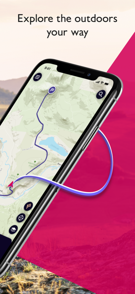
EXPLORE & PLAN HIKES, RUNS OR RIDES
Whether you are planning a walk, hike, run or ride; OS Maps lets you create outdoor adventures with trusted mapping & navigation tools from the experts at Ordnance Survey, Britain’s national mapping service.
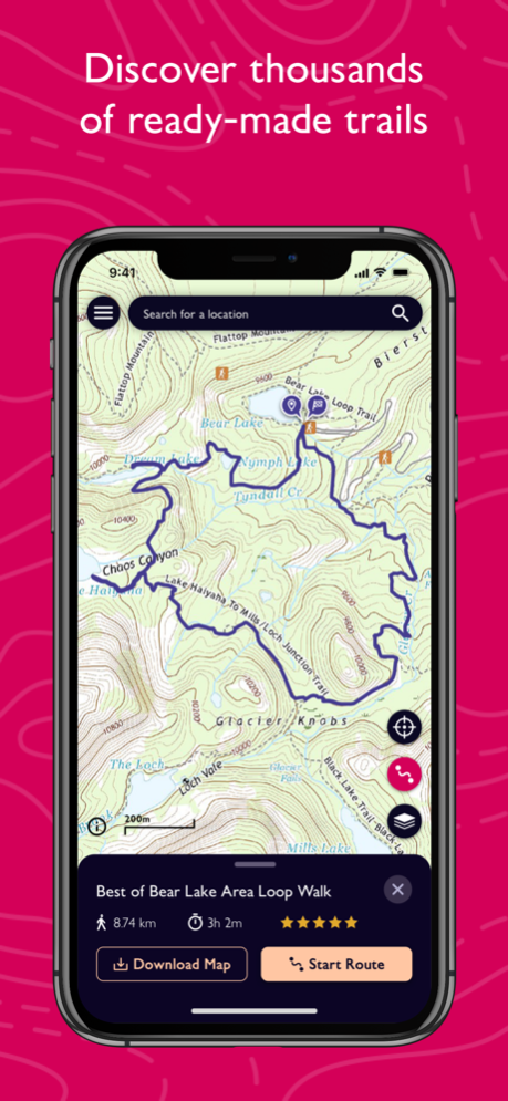
DISCOVER THOUSANDS OF READY-MADE ROUTES
Get outside with curated routes from outdoor experts & organisations such as Trail, Country Walking, Mountain Bike UK, BBC Countryfile & more.
ICONIC OS MAPPING
Subscribe to unlock the detail & accuracy of OS leisure maps including OS Explorer 1:25,000 & OS Landranger 1:50,000 & now with global mapping & topographic mapping for USA, Australia & New Zealand to keep you exploring all over the world.
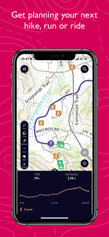
CREATE YOUR OWN ADVENTURES
Best in class route planning & navigation tools mean you can get off the beaten track & explore with more freedom. Plan routes with quick & easy snap-to-path route plotting, then save & share with your friends to plan that next epic day in the outdoors.
NO SIGNAL? NO PROBLEM
Download maps & routes to your phone to view offline, so they’re ready, whenever & wherever you need them. View any part of GB even without signal & export to your GPS device.
UNLIMITED PRINTING
Print copies of all your routes & maps to take with you, so you always have a backup to hand.
USE ON EVERY DEVICE
Sync your activities between across devices, on desktop, mobile & Apple Watch. On desktop, premium users can use our 3D Aerial Layer & route fly-throughs to see the landscape, terrain & explore in stunning 3D.
TRACK & RECORD ACTIVITIES
Use the activity recording feature to keep a log of your activity history. Follow along, save your activity, review it & turn it into a new route to share & follow again later.
RECOMMENDED BY THE EXPERTS
Ordnance Survey is proud to partner with Mountain Rescue England & Wales, with OS Maps as their recommended app to help you keep on track, & keep safe when heading outside.
TABLETOP 3D
Preview a route before you tackle it, ensure it’s suitable for your level of fitness & avoid any surprises. Our 3D model feature lets you check out your routes from the comfort of your home.
SUBSCRIPTION INFORMATION
OS Maps premium is available through a 1 month or 1 year subscription. Prices are posted in GBP but may vary by country or when converted to local currency. Subscriptions will auto-renew. Payment will be charged to iTunes Account at confirmation of purchase. The subscription automatically renews unless auto-renew is turned off at least 24-hours before the end of the current period. Your account will be charged for renewal within 24-hours prior to the end of the current period, & identify the cost of the renewal. Subscriptions may be managed by the user & auto-renewal may be turned off by going to the user's Account Settings after purchase.
Terms & Conditions at os.uk/termsosmaps
USEFUL INFORMATION
Battery life while using the app can be extended downloading maps offline prior to use, operating in Flight Mode (the GPS will still work) & turning off the screen when not in use. We release updates to all of our apps on an ongoing basis to improve stability & add extra features. Topographic mapping is available for UK (including Northern Ireland), USA, Australia & New Zealand. Your feedback & comments about this app are important to us. Leave a review or use os.uk/contact to get in touch.
*This feature uses Apple's ARKit which requires an iPhone 6s, iPhone SE, iPad 2017, iPad Pro or any later device.
Apr 17, 2024
Version 5.0.6
This latest release addresses minor bugs such as improvements to exporting a route on iPad.
Previous Versions
Here you can find the changelog of OS Maps: Walking & Bike Trails since it was posted on our website on 2020-05-15 00:17:19.
The latest version is 5.0.6 and it was updated on 2024-04-19 19:11:09. See below the changes in each version.
OS Maps: Walking & Bike Trails version 5.0.6
Updated At: 2024-04-17
Changes: Apr 17, 2024
Version 5.0.6
This latest release addresses minor bugs such as improvements to exporting a route on iPad.
OS Maps: Walking & Bike Trails version 5.0.5
Updated At: 2024-03-11
Changes: Mar 11, 2024
Version 5.0.5
This release is a major update to the app which improves the ease of use and modernises the look and feel of OS Maps.
Major changes include:
• Introduction of a 5 bar navigation menu to make it easier to find features
• New ‘Home’ tab including shortcuts, recommended partner routes, and learn tutorials
• My routes, bookmarked routes, and offline maps now all found in a convenient ‘Saved’ tab
• The app can now be viewed in light or dark mode, depending on your system settings
Additional new features include:
• When viewing a route, you can scroll the elevation chart to see height along the route
• On the Maps tab you can choose to see the mapping in full screen mode
• When plotting a route, you can now reverse route direction
• When searching for a route you can filter by circular or point to point routes
• When recording an activity, you can now minimize the recording and continue to use other app features
OS Maps: Walking & Bike Trails version 5.0.2
Updated At: 2024-02-15
Changes: Feb 15, 2024
Version 5.0.2
This release is a major update to the app which improves the ease of use and modernises the look and feel of OS Maps.
Major changes include:
• Introduction of a 5 bar navigation menu to make it easier to find features
• New ‘Home’ tab including shortcuts, recommended partner routes, and learn tutorials
• My routes, bookmarked routes, and offline maps now all found in a convenient ‘Saved’ tab
• The app can now be viewed in light or dark mode, depending on your system settings
Additional new features include:
• When viewing a route, you can scroll the elevation chart to see height along the route
• On the Maps tab you can choose to see the mapping in full screen mode
• When plotting a route, you can now reverse route direction
• When searching for a route you can filter by circular or point to point routes
• When recording an activity, you can now minimize the recording and continue to use other app features
OS Maps: Walking & Bike Trails version 5.0.1
Updated At: 2024-02-09
Changes: Feb 9, 2024
Version 5.0.1
This release is a major update to the app which improves the ease of use and modernises the look and feel of OS Maps.
Major changes include:
• Introduction of a 5 bar navigation menu to make it easier to find features
• New ‘Home’ tab including shortcuts, recommended partner routes, and learn tutorials
• My routes, bookmarked routes, and offline maps now all found in a convenient ‘Saved’ tab
• The app can now be viewed in light or dark mode, depending on your system settings
Additional new features include:
• When viewing a route, you can scroll the elevation chart to see height along the route
• On the Maps tab you can choose to see the mapping in full screen mode
• When plotting a route, you can now reverse route direction
• When searching for a route you can filter by circular or point to point routes
• When recording an activity, you can now minimize the recording and continue to use other app features
OS Maps: Walking & Bike Trails version 4.6.5
Updated At: 2023-12-14
Changes: Dec 14, 2023
Version 4.6.5
This release includes a small update to improve performance of the app.
OS Maps: Walking & Bike Trails version 4.6.4
Updated At: 2023-10-06
Changes: Oct 6, 2023
Version 4.6.4
This release includes a fix for the route line disappears when some users tap follow route.
OS Maps: Walking & Bike Trails version 4.6.3
Updated At: 2023-08-09
Changes: Aug 9, 2023
Version 4.6.3
This latest update includes small bug fixes to improve the experience.
OS Maps: Walking & Bike Trails version 4.6.2
Updated At: 2023-07-21
Changes: Jul 21, 2023
Version 4.6.2
In this latest release we’ve updated the onboarding journey for new users to make it even easier to get started with OS Maps.
OS Maps: Walking & Bike Trails version 4.6.1
Updated At: 2023-06-28
Changes: Jun 28, 2023
Version 4.6.1
Creating a route just got a whole lot easier, we’ve heard your feedback of the frustrations of only being able to snap to path when plotting a route in National Parks in GB when using the OS Leisure topographic mapping, and in this release we’ve now made it possible to snap to path any where in GB when plotting a route!
So now you can use snap to path to plot routes on OS Leisure topographic mapping from your doorstep to make it easier to get outside.
OS Maps: Walking & Bike Trails version 4.6.0
Updated At: 2023-06-19
Changes: Jun 19, 2023
Version 4.6.0
Creating a route just got a whole lot easier, we’ve heard your feedback of the frustrations of only being able to snap to path when plotting a route in National Parks in GB when using the OS Leisure topographic mapping, and in this release we’ve now made it possible to snap to path anywhere in GB when plotting a route!
So now you can use snap to path to plot routes on OS Leisure topographic mapping from your doorstep to make it easier to get outside.
Disclaimer
Official App Store Link
We do not host OS Maps: Walking & Bike Trails on our servers. We did not scan it for viruses, adware, spyware or other type of malware. This app is hosted by Apple and passed their terms and conditions to be listed there. We recommend caution when installing it.
The App Store link for OS Maps: Walking & Bike Trails is provided to you by apps112.com without any warranties, representations or guarantees of any kind, so access it at your own risk.
If you have questions regarding this particular app contact the publisher directly. For questions about the functionalities of apps112.com contact us.